At the end of September 1914, the German army managed to make a gap of more than 20 km in the French defence system, taking control of a large part of the Woëvre plain, the Meuse hills and the town of Saint-Mihiel. Hence the formation of the Saint-Mihiel Salient, a rupture in the front line. This extends from Pont-à-Mousson in the east to Les Eparges in the north, passing through Saint-Mihiel. This town, and many surrounding villages alike, remained occupied for the following four years. The region was the scene of violent fighting until its liberation in September 1918 by Franco-American troops under the command of General Pershing. Many traces of the fighting remain visible, even nowadays, in trenches, forts, and memorials.

Visual of the Saint-Mihiel Salient
© Tourist office Cœur de Lorraine
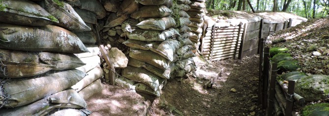
Worth a visit: the trenches in the vicinity of Saint-Mihiel – Apremont-la-Forêt
‘Tranchée de la soif’ in the Bois d’Ailly
‘Tranchée des Bavarois et de Roffignac’
‘Le Bois brûlé’ and ‘Croix des redoutes’
German trenches and concrete structures, reconstituted French trenches, firing and lookout points, memorials and explanatory panels allow you to imagine the harshness of the battles that took place here. All sites are freely accessible. Walking boots recommended.
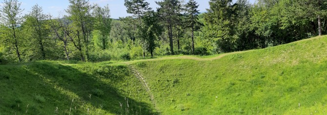
Worth a visit: the battlefield of Les Eparges
Worth a visit: the Montsec memorial
Worth a visit: the church of Marbotte
Worth a visit:
- the exhibition ‘The Saint-Mihiel Salient, from occupation to liberation’
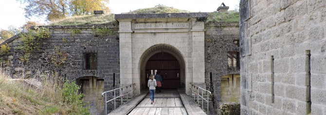
Worth a visit: the fortifications of the type ‘Séré de Rivières’
Following the defeat after the Franco-Prussian War and the annexation of Alsace-Lorraine, the French decided to erect a fortification system to protect, in particular, the new border line between France and Germany. This system is named after the project’s initiator: General Séré de Rivières.
As early as 1873 a fortified trail began to be erected, composed of forts about five to ten kilometres apart and thus capable of defending one another. Forty years later, this system played a major role during the First World War.
Visit the fort of Jouy, the fort of Liouville, and the fort of Troyon in the Coeur de Lorraine.
Also to be seen....
La Vaux-Marie
In order to encircle Verdun, the German army made a rapid advance to the west, a few days before the offensive on the Woëvre plain and the Meuse hills. To stop it, French troops, including Maurice Genevoix's 106th Infantry Division, took up position near Rembercourt. They underwent several days of intense bombardment. The German offensive was repelled on the night of the ninth to the tenth September 1914 at the cost of heavy losses.
Visit the German cemetery, the French cemetery, the monument of La Vaux Marie, and Rembercourt-Sommaisne.
La Voie Sacrée
The road linking Bar-le-Duc in the south to Verdun in the north, the so-called Voie Sacrée, was of strategic importance to the French army, during the Battle of Verdun in 1916, being the only route used to transport troops, ammunition and supplies to the front.
During the first months of this battle, more than six hundred trucks a day were used to transport thousands of men and tons of equipment on this road. It was named Voie Sacrée, the ‘Sacred Road’, at the end of the aforementioned battle, before being numbered RD1916 in 2006.